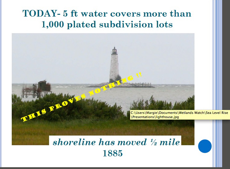
This slide was used in a Middle Peninsula Planning District presentation at a Virginia Coastal Partners Workshop in 2010. An eye-catching headline, a dramatic image, a subhead intended to reinforce an idea. Wetlands Watch supplied MPPDC with the image, and both organizations used the same picture in separate presentations at the same workshop.
Wetlands Watch used the line, “Climate Change Impacts Can be Seen in Virginia” along with “From 1885 to now–the shoreline has moved 1/2 mile.” The banner across the center of the MPPDC slide says: “THIS PROVES NOTHING!!” To which I can definitely say, You’re right! This doesn’t prove any sea level rise; it doesn’t prove climate change; and there’s a lot more to this story.
Virginia Institute of Marine Science (VIMS) did a site assessment of the New Point Comfort Lighthouse in 2008, and they noted that “erosion has always been an issue at the New Point Comfort.” The lighthouse was built on a peninsula connected to the mainland by a sandbar. Between the time the lighthouse was built in 1804 and 1832, immense areas of sand had been moved by storms, waves and wind. What follows here is the story of what was done to try to protect the lighthouse during those years, not from rising water levels, but from the relentless scouring of sand from the lighthouse island by waves and wind and storms.
The keeper reported after the Great Coastal Hurricane of 1806 that “a considerable part of the beach washed away & one of the landmarks <indicating the boundaries> was washed up, that was at the distance of 45 feet, when the public land was laid out from highwater mark.”(Candace Clifford, New Point Comfort Light Station – Historical Documentation, 2001) “This hurricane, due to its slow movement and consequent erosion of the coastline completed the formation of Willoughby Spit. A seawall built to prevent further erosion at Smith Point Lighthouse was damaged.” (http://www.hpc.ncep.noaa.gov/research/roth/vaerly19hur.htm)
In 1814, the first report of the extensive damage the British did to the lighthouse in the War of 1812 suggested the lighthouse should be destroyed if the war continued because it was being used as a watchtower, and “the water already washes its base and in a few years will undermine it.” (Clifford, 2001 quoting from the National Archives.) That advice was not followed and in 1815, the original builder recommended 156 pilings of 12-14 ft be sunk 5-6 ft in the sand, and another 100 opposite the house to protect it.
A year later, sand had begun to collect around the pilings and the lighthouse was considered secure. Unfortunately, by 1822, those pilings had rotted in the ground. A stone wall was then approved in 1825, and still more repairs and additional work were done in 1832.
The National Archives holds a request for a boat in 1839 because, “There is now two miles of water communication necessary where until lately there was a ford at low tide.” In 1846, the keeper reported the “publick buildings were completely surrounded by tidewater.” (Candace Clifford, 2001)
The lighthouse was put out of commission during the War Between the States in 1861, restored in 1865, and once again, a boat was requested for the keeper in 1866. Sand moved and shoals formed in the decades that followed, and gales and hurricanes moved and changed them as they always have. But that’s a function of weather, normal, ordinary weather–capricious and unpredictable, not because of climate change.
The next post will take a look at what happened to the 1904 1,000 lot subdivision of the New Point Comfort Development Company. Or, perhaps more accurately, what didn’t happen.
* * *
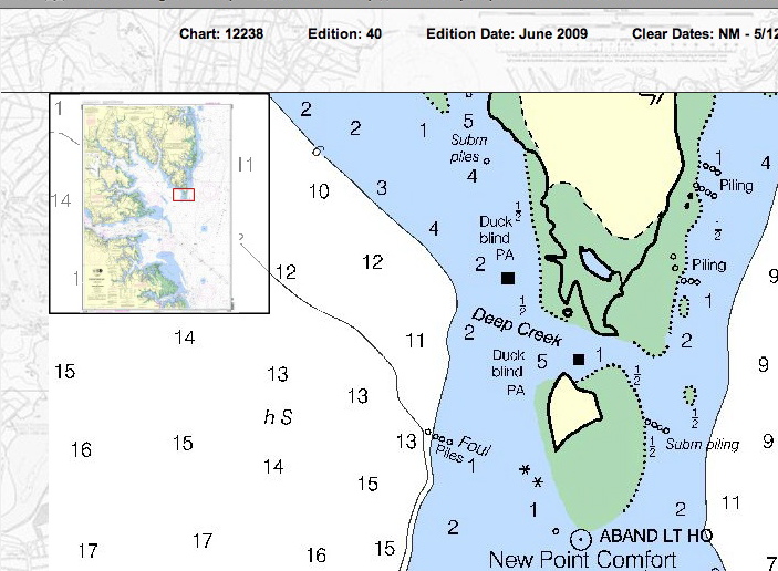
Below is a detail from NOAA Nautical Chart 12238, showing water depth in feet in 2009 around New Point Comfort Lighthouse island. (Green areas are marshes.) One small area to the northwest, between the lighthouse and the shoreline is 5 ft as the MPPDC/Wetlands Watch slide said, but north, past a marshy area, it’s 1 ft; to the northeast, 1/2 ft, and east-northeast, 2 ft.


