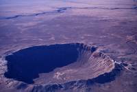
Barringer Crater in Arizona
The idea of living inside an impact crater fascinates me. Here’s some background on the one I call home: The Chesapeake Bay Impact Crater’s central area is about 56 miles (90km) across and about .81 miles (1.3km) deep, making it the largest in the United States and the 6th largest in the world. To give you an idea of what the crater would look like if it weren’t under the Bay and filled with marine sediments, take a look at this photo of the Barringer Crater in Arizona, about 600 ft deep and 4,000 ft in diameter. (Image Courtesy: Michael Collier; Image source: Earth Science World Image Bank, Copyright Michael Collier. http://www.earthscienceworld.org/image)
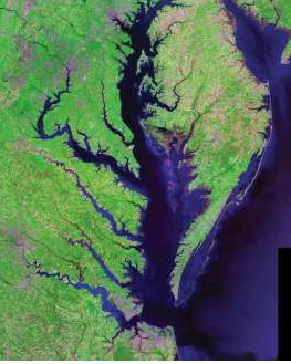
Rivers bend 90º at the edge of the crater. Image Courtesy of USGS/NASA Landsat
Our Chesapeake Bay Impact Crater kept its identity a secret for a good bit of its 35 million year existence. Some material was vaporized when the bolide struck; some was thrown into the air and fell back in a jumble trapping pockets of ancient seawater; some was melted and flung into the air, falling as glassy blobs called tektites as far away as Georgia and Texas. Over the eons, marine sediments filled in part of the crater and disguised its origin.
But it was the discovery of “shocked” quartz in undersea core samples off the New Jersey coast that led C.Wylie Poag, chief scientist on the Glomar Challenger, to search for the impact area. Two United States Geological Survey (USGS) papers, explain the formation of the crater: one from 1998 by C. Wyle Poag, “USGS Fact Sheet 049-98,” and another with more technical information from 2000 by David S. Powars, “The Effects of the Chesapeake Bay Impact Crater on the Geologic Framework and the Correlation of Hydrogeologic Units of Southeastern Virginia, South of the James River.”