By G. C. Morrow
After reviewing VDOT’s current Mathews Courthouse drainage project (VDOT #87865), I decided to look at previous projects to see if I could find a pattern in their failures. It is extremely hard to conceive that these projects with their half million plus engineering budgets fail so miserably at their purpose. At first glance, it appears that the engineers are attempting to move their drainage conveyances to more accessible locations, but even the greenest of engineers should know better than to try to drain water uphill.
Case in point is the Wards Corner Project at Routes 14 and 198 (VDOT# 56940). VDOT has two outfalls just north of Wards Corner on Rt. 198 that are so neglected they can only be found by locating the endwalls and large pipes. South of Wards Corner, there are 3 outfalls much lower in elevation than the one at Wards Corner, and they are necessary to handle several hundred acres of stream flow, as well as roadside drainage. All roadside ditches in this vicinity are so poorly maintained that the flow lines are almost completely lost, and many large pipes are obscured in the right-of-way.
Wards Corner, July 21, 2012 Photo: C. J. Bova
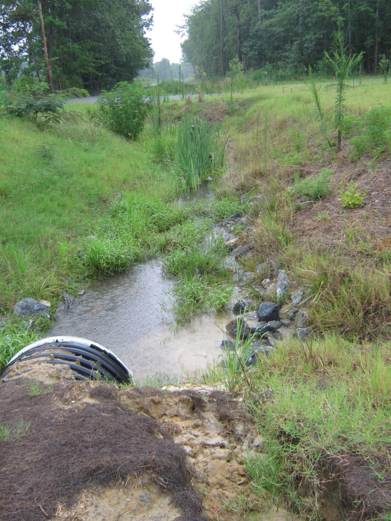
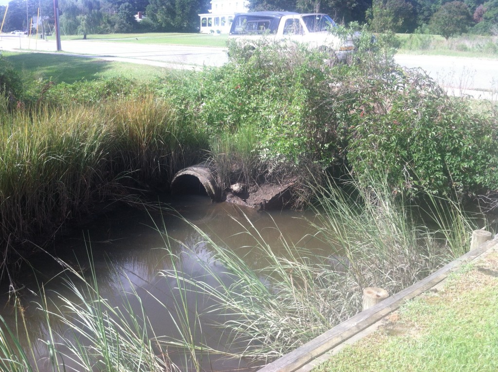
The Mathews High School football field and the Mathews County Park on 198 have been flooded several times since the Wards Corner Project completion. On one occasion, I photographed a 200′ wide river on our football field and park. At the same time, the pipes at Wards Corner were less than half full because water still goes downhill, and the high school is downhill from Wards Corner.
High school football field Aprl 15, 2014 Photo: GC Morrow
This $1.618 million project was a gross waste of resources and will cause perpetual flooding of downstream locations and personal property from roads that still need proper and adequate conveyance of storm water and stream flow. VDOT could have invested a much smaller amount to restore the outfall to Stutts Creek behind the high school, and clear or even replace the pipes in the VDOT easement along the football field, and convey the water from Route 198 and not let it flood the school and park properties. (See State Highway Plat Book 3, pg. 211, 0014 057 305.)
An earlier project on East River Road, Route 660 (VDOT #61013) $1.334 million, did not address Route 14 drainage between Route 660 at Foster and Route 617 at North. The roadside ditches less than .25 mile west of Foster are flooded most of the time. The 1965 USGS topographic map shows that three uphill streams that should cross Route 14 are channelized to roadside ditches in the VDOT right-of-way. The adjacent properties are now flooded along the roadside ditch. No matter how well a project is engineered and designed, if necessary adjacent conveyances are not maintained, any project can negatively impact the already neglected system.
The Mathews Courthouse Route 14 Drainage Improvement Project (#87865) is another case of a poorly engineered and designed package. The engineers relied on computer-generated maps without ground verification to identify the drainage areas. The 2011 USGS topo included historical drainage ditches which no longer function, and in some cases, no longer exist. That 2011 map also labeled a ditch north of the Hyco Subdivision as Put In Creek. First, it’s barely identifiable today, and second, it’s a created drainage ditch, not Put In Creek, and third, it is downhill from the planned location of the four new pipes crossing 198 to Put In Creek.
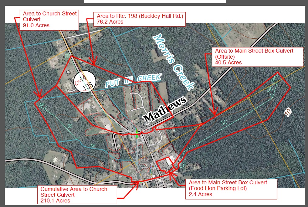
VDOT Route 14 Drainage Improvement Plan Map pg. 10
Most of the drainage areas in the plan are overstated because the natural drainage pattern for them would be to the Morris Creek watershed, not to the Put In Creek/East River watershed. The boundary between the Morris Creek and Put In Creek watersheds is incorrect on both national and state maps. The 198 connection to the Put In Creek ditch could be adequate to carry water from the road, but not any of the Morris Creek watershed.
If the original ditches were functioning properly, the water from the Hyco Subdivision and adjacent land would go to Morris Creek by two routes.
Ditch 1. runs parallel to Route 198 north to Critter Lane where it can enter Morris Creek, but the ditch is constrained by a collapsed 15″ pipe.
Ditch 2 is to the east of Hyco Subdivision where VDOT has an 800’ outfall. (198-4957-02, sheet 5) The deeded 800’ outfall follows the proper contour northward to Morris Creek. This conveyance has a dimension of approximately 12′ wide and 7′ deep at the tree line, then it tapers down to 2′ wide 2′ deep approximately 300′ from the roadside. The landowners adjacent to this failed ditch have documented many complaints about standing water on their property to VDOT without response.
The plan also shows water being directed to Put In Creek from the Liberty Square Courthouse to Church Street through a ditch system which failed a long time ago. The plan does not address restoring it.
More than 100 acres of water from part of Glebe Road, the rest of the Liberty Square Courthouse, the Cricket Hill Apartments, and Bank of America crosses under Route 198 to the east to an outfall at 10601 Buckley Hall Road. This is part of the same Ditch 1 listed under Hyco Subdivision which goes to Critter Lane and Morris Creek.
Both Ditch 1 and Ditch 2 have partly failed and have created several acres of flooded upland, now being called nontidal wetlands.
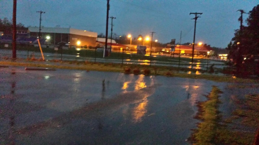
Like the situation with Hyco Subdivision, the water from the land behind Food Lion should drain to Morris Creek, not Put In Creek. Because the original ditches that conveyed the water to Morris Creek no longer function, water leaves the Food Lion parking lot via a 48” pipe near the Chinese restaurant then funnels east into the woods behind the Food Lion. When rain exceeds 1″ an hour for 3 or 4 hours, the woods store water until the ground is saturated. The water then converts to a 70-acre sheet flow, where every drop falling on this land has to go uphill to Food Lion, and then to Faulkner and Son. This conveys torrents of water to Main Street and continues to run for days.
When I approached the lead engineer at the public design hearing, he was rather arrogant and abrasive, and stressed his job was to drain the 70 acres. The map he provided showing the lands to be drained showed no houses, no businesses, no roads, and that the drainage area was definitely downhill from Food Lion.
The median storm water level already overtops the Put In Creek ditch and adjacent property located behind Faulkner and Son. I could say much more, and I have spoken to Jim Brent, P.E., Sean Trapani, former Saluda R.A., Delegate Keith Hodges, Planning and Zoning Director John Shaw, and several engineers at the public design hearing. But there has been no change in the project except to increase the cost.
The unanswered questions are:
- Why hasn’t VDOT explored the possibility that the two existing pipes across Buckley Hall Road, including the one destroyed by utility pole placement years ago, might be adequate in conjunction with system maintenance and restoration?
- The new Westville Community project shows water discharge at 7.75 ft. elevation into the VDOT pipe system which shows a 5.42 ft. elevation at its discharge point (per VDOT plans). Will this 13 acres of additional storm water flow uphill to Hyco Corner? Or will it further damage the properties downhill to the east of the Westville Community project?
- Why hasn’t VDOT realized any additional water collected at Buckley Hall Road will exceed the capacity of the feeble ditch between Hyco Corner and Church Street (Route 611) at the Firehouse?
- Two 4’ x 7’ box culverts are 2.91 times larger than the two 42” pipes now at Church Street. They are intended to let more water out, but will definitely let more water in as well.
Put In Creek at Church Street 42″ pipe two hours before predicted low tide of .28 ft
- Did anyone with tidal engineering or analysis experience review the plans that use a high tide water surface elevation of 0.31 feet when high tides range from 1.8 to over 3 feet?
Put In Creek after 2.9 ft high tide Photo: CJ Bova
I hope that someone at VDOT will ground verify and redesign this poorly conceived project that will definitely increase the probability and severity of flooding–both tidal and non-tidal.
Notice how the original outfalls traveled great distances to avoid any close tidal contact. This is another no-brainer that can’t be taught. We expect more from over $945,000 than bad, poorly directed engineering.
G.C. Morrow’s family‘s roots in Mathews go back to 1725. He’s worked in, traveled through, or explored most all of the county. He is co-founder of the Ditches of Mathews County Project which has worked to raise awareness of the problems and offer solutions to VDOT’s drainage issues that are affecting Mathews County.
He’s worked and fought with many state and federal agencies for the environmental well-being of Mathews and was one of the citizens on the county’s Ditch Enhancement project Committee who tried to provide local knowledge to the engineers. As Business Group Chair on the Piankatank TMDL Steering Committee to improve water quality, he fought for truth in reports and provided more accurate information than the state’s computer-generated numbers for wildlife, livestock and pet populations. In January 2016, G.C. began his first term on the Mathews County Board of Supervisors. This open letter is a personal statement of his views based on his experience and knowledge of Mathews County.