
By Carol J. Bova
(Originally posted as a response to James A. Bacon’s blog, “Does “Ooker” Estridge Know Something the Experts Don’t” on Bacon’s Rebellion about sea level rise impacting Tangier Island in the Chesapeake Bay. Tangier Island is losing about 16 feet a year on its western side and 3 on the eastern.)
Too bad no one considered this kind of replenishment for Tangier Island while there was a better chance of saving it.
“Ooker” Estridge is right that Tangier Island’s problem is erosion, and he’s got hard science behind that statement. While sea level rise is a long-term issue and increased monitoring of local impacts is important, that’s not why Tangier Island is endangered. Lewisetta is the nearest tide gauge and not out in the Bay, but the local sea level trend is 1.7 ft in 100 years, which is less than a quarter inch per year. So there’s more in play there.
“Storms provide the greatest source of coastal change on barrier islands due to storm surge and strong waves. Surging water and stronger waves can erode barrier island beaches and, if the surge is high enough, result in overwash, breaching, or back bay flooding… .” (U S Army Corps of Engineers, North Atlantic Coast Comprehensive Study: Resilient Adaptation to Increasing Risk. January 2015.)
Tangier Island is a barrier island, and like all barrier islands and barrier beaches, it’s made up of sand-sized sediment that is deposited, moved, and reformed by wind and waves. Political positions about sea level rise have ignored the reality of longshore transport of sediment (also called longshore drift). If the sand supply is not maintained, the island erodes to the point where it is inundated by the tides. No one realized in the 1700s how fragile these bodies are, or that it wasn’t a good idea to build on them.
NOAA relates the story of Tucker Island in New Jersey, settled in 1735, and how attempts to stop longshore transport of sand using jetties in 1924 eventually caused the loss of that barrier island.
We have the same problem on the Chesapeake Bay coastline in Mathews County where we’ve just about lost Rigby Island, another barrier island, and have a breach in the Winter Harbor barrier beach caused by a nor’easter in 1978. Beach replenishment could repair it and restore the protective function of the barrier beach against storm surge flooding, but the Virginia Institute of Marine Science and the Corps of Engineers chose instead to only supplement the tiger beetle habitat below the breach, allowing the breach to continue to widen.
The Virginia Department of Transportation helped create the problem by removing 5-7 feet of sand from the beaches to the north of Winter Harbor in the 1930s and 1940s to use to build roads in two counties. (This was confirmed by a memo in VDOT’s files.)
The Corps of Engineers also helped create the problem by working with the County to open a channel directly from Garden Creek to the Bay. The jetties they built to keep the channel open failed, but they also prevented the movement of sand southward to the Winter Harbor barrier beach leading to its breach.
Wetlands Watch joined with the Middle Peninsula Planning District Commission (MPPDC) in blaming sea level rise for the loss of the barrier beach and barrier island around the New Point Comfort Lighthouse in the NOAA grant-funded MPPDC Climate Change Adaptation Phase 2 report and repeated the claim in the 2011 Phase 3 report with slides implying sea level rise causes the lighthouse to be left on a tiny island. One has picture of the lighthouse in 1885 and “today” with the caption, “shoreline has moved 1/2 mile.” Another says, “TODAY – 5 ft water covers more than 1,000 plated subdivision lots.”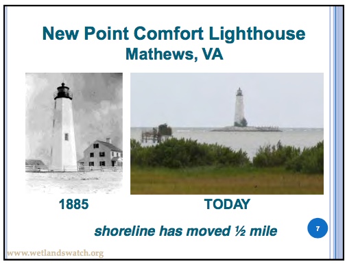
The platted subdivision only existed on paper because the project failed financially in 1905. Much of the barrier island and barrier beach were lost in the 1933 August and September hurricanes, and the rest lost through longshore transport after that.
The reports include those slides and a mocking cartoon about the “Coconut Telegraph,” alluding to person-to-person communication between Mathews citizens, as part of Power Point presentations made throughout Virginia and in other areas on sea level rise by MPPDC Executive Director, Lewie Lawrence.
When local observations are ignored in favor of political positions, everyone loses. Tax money is spent on the wrong responses and real problems get worse because they’re not acknowledged.
People who come from generations who’ve lived in the same place may not have the university degrees, but they have knowledge that could benefit the universities and government agencies who disregard them.
In the http://www.nad.usace.army.mil/Portals/40/docs/NACCS/NACCS_main_report.pdf”Hurricane Sandy report, the Corps of Engineers places barrier island and barrier beach preservation among the highest Coastal Storm Risk Management and Resilience measures, short of removing buildings from the coast.